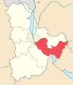
Boryspil Raion
Бориспільський район | |
|---|---|
| Бориспільський район (Boryspilskyi raion) | |
 Boryspil Raion after the 2020 raion reform | |
| Coordinates: 50°14′24″N 30°59′39″E / 50.24000°N 30.99417°E | |
| Country | |
| Oblast | |
| Established | 1923 |
| Admin. center | Boryspil |
| Subdivisions | 11 hromadas |
| Government | |
| • Governor | Ivan Pavlovych Poliukhovych |
| Area | |
• Total | 3,873.2 km2 (1,495.5 sq mi) |
| Population (2022)[1] | |
• Total | 203,154 |
| • Density | 52/km2 (140/sq mi) |
| Time zone | UTC+02:00 (EET) |
| • Summer (DST) | UTC+03:00 (EEST) |
| Postal index | 083 |
| Area code | 380-44 |
| Website | kyiv-obl.gov.ua |
Boryspil Raion (Ukrainian: Бориспільський район, romanized: Boryspil's'kyi raion) is an administrative raion (district) in east-central Kyiv Oblast of Ukraine. Its administrative center is the city of Boryspil. Population: 203,154 (2022 estimate).[1]
On 18 July 2020, as part of the administrative reform of Ukraine, the number of raions of Kyiv Oblast was reduced to seven, and the area of Boryspil Raion was significantly expanded. Two abolished raions, Pereiaslav-Khmelnytskyi and Yahotyn Raions, as well as the cities of Boryspil and Pereiaslav, which were previously incorporated as cities of oblast significance and did not belong to the raion, were merged into Boryspil Raion.[2][3] The area of the raion before the reform was 146 square kilometres (56 sq mi). The January 2020 estimate of the raion population was 53,619 (2020 est.).[4]
- ^ a b Чисельність наявного населення України на 1 січня 2022 [Number of Present Population of Ukraine, as of January 1, 2022] (PDF) (in Ukrainian and English). Kyiv: State Statistics Service of Ukraine. Archived (PDF) from the original on 4 July 2022.
- ^ "Про утворення та ліквідацію районів. Постанова Верховної Ради України № 807-ІХ". Голос України (in Ukrainian). 2020-07-18. Retrieved 2020-10-03.
- ^ "Нові райони: карти + склад" (in Ukrainian). Міністерство розвитку громад та територій України.
- ^ Чисельність наявного населення України на 1 січня 2020 року / Population of Ukraine Number of Existing as of January 1, 2020 (PDF) (in Ukrainian and English). Kyiv: State Statistics Service of Ukraine. Archived (PDF) from the original on 28 September 2023.


