| Bosut | |
|---|---|
 Bosut between Rokovci and Andrijaševci | |
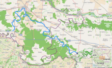
 Bosut location [1] | |
| Location | |
| Countries | |
| Physical characteristics | |
| Source | |
| • location | near Cerna, Croatia |
| • coordinates | 45°05′46″N 18°40′36″E / 45.09611°N 18.67667°E |
| Mouth | |
• location | Sava at the village of Bosut, Serbia |
• coordinates | 44°56′28″N 19°22′14″E / 44.9411°N 19.3706°E |
| Length | 186 km (116 mi) [1] |
| Basin size | 2,943 km2 (1,136 sq mi) [1] |
| Basin features | |
| Progression | Sava→ Danube→ Black Sea |
 | |
The Bosut (Serbian Cyrillic: Босут) is a river in the Syrmia region of eastern Croatia and northwestern Serbia. It is a 186 km long, slow and meandering left tributary of the Sava river.[2]
The riverbed begins near the left embankment of the Sava river between Županja and Štitar (45°05′46″N 18°40′36″E / 45.09611°N 18.67667°E),[3] which in the past[4][5] was an outflow channel, and a connection with the Sava. Some 2,400 m (1.5 mi) farther, the Bosut gets its first water from the Berava river (45°06′59″N 18°40′45″E / 45.11639°N 18.67917°E). The narrow riverbed widens in Cerna, where it receives the water of the Biđ.[6][3]
The river continues north toward the city of Vinkovci, the only major city on its course, and then turns southeast. Near Lipovac it receives its major tributary Spačva, and then enters Serbia near Batrovci. In its lower course, Bosut flows through a forested area in the Spačva region.
The river is known for its abundance of fish.[7] It is thought that its name derives from the Indo-European root *bhogj, meaning "to flow". The same root is seen in hydronym "Bosna".[8]
- ^ a b "Sava River Basin Analysis Report" (PDF). International Sava River Basin Commission. September 2009. p. 14. Archived from the original (PDF, 9.98 MB) on 2010-07-17.
- ^ Ostroški, Ljiljana, ed. (December 2015). Statistički ljetopis Republike Hrvatske 2015 [Statistical Yearbook of the Republic of Croatia 2015] (PDF). Statistical Yearbook of the Republic of Croatia (in Croatian and English). Vol. 47. Zagreb: Croatian Bureau of Statistics. p. 49. ISSN 1333-3305. Retrieved 27 December 2015.
- ^ a b Marušić, Josip (2017). "Stručni prikaz: Višenamjenski kanal Dunav-Sava. Preduvjet za poboljšanje vodnog režima Bosuta". Hrvatske vode (in Croatian). 25 (101).
- ^ "Slawonische Militärgrenze (1780) - First Military Survey". Arcanum Maps. Retrieved 2024-09-25.
- ^ "Croatia (1865–1869) - Second military survey of the Habsburg Empire". Arcanum Maps. Retrieved 2024-09-25.
- ^ Orban-Kljajić & Kljajić 2003, p. 599.
- ^ "Bosut". Hrvatska enciklopedija (in Croatian). Leksikografski zavod Miroslav Krleža. Retrieved 2024-09-25.
- ^ Mayer, Antun (1935). "Ime Mursa". Vjesnik Arheološkog muzeja u Zagrebu. 16 (1): 7. Retrieved 2022-06-16.