Botkins, Ohio | |
|---|---|
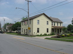
 Streetside view of Shelby House in Botkins | |
 Location of Botkins, Ohio | |
 Location of Botkins in Shelby County | |
| Coordinates: 40°28′04″N 84°11′09″W / 40.46778°N 84.18583°W | |
| Country | United States |
| State | Ohio |
| County | Shelby |
| Government | |
| • Mayor | Lance Symonds[1] |
| • Village Administrator | Randy Purdy[2] |
| Area | |
| • Total | 1.27 sq mi (3.30 km2) |
| • Land | 1.26 sq mi (3.27 km2) |
| • Water | 0.01 sq mi (0.03 km2) |
| Elevation | 1,004 ft (306 m) |
| Population (2020) | |
| • Total | 1,155 |
| • Estimate (2023)[5] | 1,176 |
| • Density | 914.49/sq mi (353.12/km2) |
| Time zone | UTC-5 (Eastern (EST)) |
| • Summer (DST) | UTC-4 (EDT) |
| ZIP code | 45306 |
| Area code(s) | 937, 326 |
| FIPS code | 39-07832[6] |
| GNIS feature ID | 2398153[4] |
| Website | http://www.botkinsohio.com |
Botkins is a village in Shelby County, Ohio, United States. The population was 1,155 at the 2020 census.
Botkins is located alongside Interstate 75 at Exit 104. Botkins is at the northern edge of Shelby County, immediately south of its border with Auglaize County. It also lies at the northern edge of the 937 area code.
- ^ Purdy, Randy. "Village Administrator". Botkins Ohio. Retrieved August 9, 2024.
- ^ Purdy, Randy. "Village Administrator". Botkins Ohio.
- ^ "ArcGIS REST Services Directory". United States Census Bureau. Retrieved September 20, 2022.
- ^ a b U.S. Geological Survey Geographic Names Information System: Botkins, Ohio
- ^ "Annual Estimates of the Resident Population for Incorporated Places in Ohio: April 1, 2020 to July 1, 2023". United States Census Bureau. Retrieved June 4, 2024.
- ^ "U.S. Census website". United States Census Bureau. Retrieved January 31, 2008.
