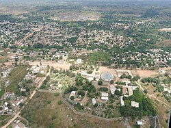
Bouar
Buar[1] | |
|---|---|
 Bouar | |
| Coordinates: 5°57′N 15°36′E / 5.950°N 15.600°E | |
| Country | Central African Republic |
| Prefecture | Nana-Mambéré |
| Government | |
| • Sub-prefect | Jean Michel Bouaka[2] |
| • Mayor | Dieu-Beni Massina[3] |
| Elevation | 1,046 m (3,432 ft) |
| Population (2012)[4] | |
• Total | 39,205 |
Bouar is a market town in the western Central African Republic, lying on the main road from Bangui (437 km) to the frontier with Cameroon (210 km). The city is the capital of Nana-Mambéré prefecture, has a population of 40,353, while the whole sous-préfecture has a population of 96,595 (2003 census). Bouar lies on a plateau almost 1000m above sea level and is known as the site of Camp Leclerc, a French military base.
About seventy groups of megaliths lie in the town and to its north and east. The Bouar Megaliths, dating back to the very late Neolithic Era (c. 3500–2700 BC) were added to the UNESCO World Heritage Tentative List on April 11, 2006 in the Cultural category.[5]
The town's name comes from the Gbaya word for bean, hbouar.[6]
- ^ Buar (Variant) at GEOnet Names Server, United States National Geospatial-Intelligence Agency
- ^ Oubangui Medias, Oubangui Medias. "Centrafrique : Décrets portant nomination des Gouverneurs, des Préfets et des Sous-Préfets". oubanguimedias.com. Oubangui Medias. Retrieved 5 June 2024.
- ^ Ndeke Luka, Ndeke Luka. "Face à l'insalubrité dans la ville de Bouar, Dieu-Beni Massina lance des initiatives". radiondekeluka.org. Radio Ndeke Luka. Retrieved 14 August 2023.
- ^ "World Gazetteer". Archived from the original on 2013-01-11.
- ^ Les mégalithes de Bouar - UNESCO World Heritage Centre
- ^ Degras, Alain (2012). Akotara: Un triptyque consacré aux Gbayas du Nord-Ouest Centrafricain (PDF) (in French). Bouar: Order of Friars Minor Capuchin. pp. 20, 62. Archived from the original (PDF) on 21 July 2022.
