| Boulder Kalgoorlie, Western Australia | |||||||||||||||
|---|---|---|---|---|---|---|---|---|---|---|---|---|---|---|---|
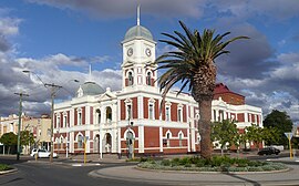
 Boulder Town Hall | |||||||||||||||
 | |||||||||||||||
| Coordinates | 30°46′55″S 121°29′19″E / 30.78194°S 121.48861°E | ||||||||||||||
| Population | 4,872 (SAL 2021)[1] | ||||||||||||||
| Postcode(s) | 6432 | ||||||||||||||
| Elevation | 355 m (1,165 ft) | ||||||||||||||
| Area | 4.5 km2 (1.7 sq mi) | ||||||||||||||
| Location |
| ||||||||||||||
| LGA(s) | City of Kalgoorlie–Boulder | ||||||||||||||
| State electorate(s) | Kalgoorlie | ||||||||||||||
| Federal division(s) | O'Connor | ||||||||||||||
| |||||||||||||||
Boulder is a suburb[2] of Kalgoorlie in the Western Australian Goldfields, 597 kilometres (371 mi) east of Perth.
The Boulder (horse) Races were a significant event in early twentieth century goldfields region history.[3][4][5]
The town maintained its separation from Kalgoorlie until the 1980s, however even prior to that era, many surveys and studies of the towns and their areas tended to join the names.[6][7][8]
Prior to 1989, Boulder was a town, but it was merged with Kalgoorlie to form the City of Kalgoorlie–Boulder.
The population of Boulder in 1901 was 2,936 (1850 males and 1086 females), which increased to 5,658 (3090 males and 2568 females) in 1903.[9]
At the 2006 census, Boulder had a population of 5,178.[10] This had decreased to 4,825 by the 2016 census.[11]
On 20 April 2010 Kalgoorlie-Boulder suffered a magnitude 5.0 earthquake which damaged several of the historic buildings in Boulder.[12]
- ^ Australian Bureau of Statistics (28 June 2022). "Boulder (suburb and locality)". Australian Census 2021 QuickStats. Retrieved 28 June 2022.
- ^ "Race tensions ramp-up in Kalgoorlie again as Facebook clashes continue". 25 March 2018.
- ^ "RACING IN WESTERN AUSTRALIA". The Argus (Melbourne). No. 18, 305. Victoria, Australia. 16 March 1905. p. 8. Retrieved 3 November 2018 – via National Library of Australia.
- ^ "Western Australia". Observer. Vol. LXVI, no. 5, 243. South Australia. 28 August 1909. p. 23. Retrieved 3 November 2018 – via National Library of Australia.
- ^ "RACING IN WESTERN AUSTRALIA". The Argus (Melbourne). No. 22, 796. Victoria, Australia. 25 August 1919. p. 9. Retrieved 3 November 2018 – via National Library of Australia.
- ^ Margaret A. Feilman & Partners; National Estate Grants Program (Australia) (1975), Kalgoorlie – Boulder historic survey : a survey of the towns of Kalgoorlie Boulder in Western Australia for the Kalgoorlie-Boulder Joint Town Planning Committee, Perth, retrieved 3 November 2018
- ^ Newbould, Jennifer; Goldfields Youth Management Committee (W.A.); Western Australia. Department for Youth, Sport and Recreation. Goldfields Regional Office (1983), A base data analysis into the extent of the provision of existing youth leisure services in the area of Kalgoorlie/Boulder, Western Australia, Goldfields Youth Management Committee [and] Dept. for Youth, Sport and Recreation, Goldfields Regional Office, retrieved 3 November 2018
- ^ Western Australia. Department of Land Administration (1988), Town of Kalgoorlie—Shire of Boulder structure plan : planning report, October 1988, Department of Land Administration, retrieved 3 November 2018
- ^ "West Australia". Kalgoorlie Western Argus. Western Australia: National Library of Australia. 9 June 1903. p. 32. Retrieved 27 March 2014.
- ^ Australian Bureau of Statistics (25 October 2007). "Boulder (State Suburb)". 2006 Census QuickStats. Retrieved 10 July 2009.
- ^ Australian Bureau of Statistics (27 June 2017). "Boulder (State Suburb)". 2016 Census QuickStats. Retrieved 1 February 2018.
- ^ "Earthquake rocks Kalgoorlie-Boulder". 20 April 2010.