Bowdoin, Maine | |
|---|---|
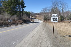
 Maine State Route 125 Going into Bowdoin Center from Bowdoinham | |
| Coordinates: 44°2′53″N 69°58′6″W / 44.04806°N 69.96833°W | |
| Country | United States |
| State | Maine |
| County | Sagadahoc |
| Incorporated | 1788 |
| Area | |
| • Total | 43.58 sq mi (112.87 km2) |
| • Land | 43.46 sq mi (112.56 km2) |
| • Water | 0.12 sq mi (0.31 km2) |
| Elevation | 295 ft (90 m) |
| Population (2020) | |
| • Total | 3,136 |
| • Density | 27.9/sq mi (10.8/km2) |
| Time zone | UTC-5 (Eastern (EST)) |
| • Summer (DST) | UTC-4 (EDT) |
| ZIP code | 04287 |
| Area code | 207 |
| FIPS code | 23-06260 |
| GNIS feature ID | 0582360 |
| Website | bowdoinmaine |
Bowdoin is a town in Sagadahoc County, Maine, United States. Bowdoin is included in the Lewiston-Auburn, Maine metropolitan New England city and town area. The population was 3,136 at the 2020 census.[2] Bowdoin is 31 land miles north of Portland, and 21 land miles south of Augusta (Maine’s state capital).
- ^ Cite error: The named reference
Gazetteer fileswas invoked but never defined (see the help page). - ^ "Census - Geography Profile: Bowdoin town, Sagadahoc County, Maine". Retrieved January 15, 2022.
