| Bowen Basin | |
|---|---|
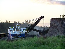
 Digging overburden at Dawson Mine near Moura, 2008 | |
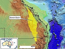
 Map showing the location of Bowen Basin in relation to Australia | |
| Coordinates | 23°10′39.55″S 148°22′22.80″E / 23.1776528°S 148.3730000°E |
| Etymology | Bowen River, George Bowen |
| Country | |
| State(s) | Queensland, New South Wales (minor) |
| Cities | Collinsville, Theodore |
| Characteristics | |
| On/Offshore | Onshore |
| Boundaries | Atherton Tableland |
| Part of | Galilee Basin |
| Area | ~60,000 km2 (23,000 sq mi) |
| Hydrology | |
| River(s) | Bowen River |
| Geology | |
| Basin type | Rift basin |
| Plate | Australian |
| Orogeny | Hunter-Bowen |
| Age | Permian-Holocene |
| Stratigraphy | Stratigraphy |
| Field(s) | Bowen Basin Coalfields |
The Bowen Basin contains the largest coal reserves in Australia. This major coal-producing region contains one of the world's largest deposits of bituminous coal. The Basin contains much of the known Permian coal resources in Queensland including virtually all of the known mineable prime coking coal. It was named for the Bowen River, itself named after Queensland's first Governor, Sir George Bowen.
The Bowen Basin covers an area of over 60,000 square kilometres in Central Queensland running from Collinsville to Theodore. There was a combined population of 41,973 people in the area in 2001. The ornamental snake is a small reptile native to the Bowen Basin region.
