| Bredbo New South Wales | |||||||||||||||
|---|---|---|---|---|---|---|---|---|---|---|---|---|---|---|---|
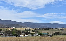
 Bredbo, 2020 | |||||||||||||||
| Coordinates | 35°57′0″S 149°09′0″E / 35.95000°S 149.15000°E | ||||||||||||||
| Population | 352 (2016 census)[1] | ||||||||||||||
| Postcode(s) | 2626 | ||||||||||||||
| Elevation | 704 m (2,310 ft) | ||||||||||||||
| Location | |||||||||||||||
| LGA(s) | Snowy Monaro Regional Council | ||||||||||||||
| State electorate(s) | Monaro | ||||||||||||||
| Federal division(s) | Eden-Monaro | ||||||||||||||
| |||||||||||||||
Bredbo is a village on the Monaro plains of New South Wales, Australia.[2][3] The village is on the Monaro Highway 34 kilometres (21 mi) north of Cooma. The village is in the Snowy Monaro Regional Council and had a population of 352 at the 2016 census.[1]
- ^ a b Australian Bureau of Statistics (27 June 2017). "Bredbo (State Suburb)". 2016 Census QuickStats. Retrieved 7 July 2017.
- ^ "Bredbo". Geographical Names Register (GNR) of NSW. Geographical Names Board of New South Wales. Retrieved 16 August 2017.
- ^ "Bredbo". OpenStreetMap. Retrieved 16 August 2017.
