Brekken Municipality
Brekken herred | |
|---|---|
 View of the municipal government building | |
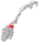
 Sør-Trøndelag within Norway | |
 Brekken within Sør-Trøndelag | |
| Coordinates: 62°38′50″N 11°52′20″E / 62.6473°N 11.8721°E | |
| Country | Norway |
| County | Sør-Trøndelag |
| District | Gauldalen |
| Established | 1926 |
| • Preceded by | Røros Municipality |
| Disestablished | 1 Jan 1964 |
| • Succeeded by | Røros Municipality |
| Administrative centre | Brekken |
| Area (upon dissolution) | |
• Total | 843 km2 (325 sq mi) |
| Population (1964) | |
• Total | 964 |
| • Density | 1.1/km2 (3.0/sq mi) |
| Demonym | Brekking[1] |
| Official language | |
| • Norwegian form | Neutral |
| Time zone | UTC+01:00 (CET) |
| • Summer (DST) | UTC+02:00 (CEST) |
| ISO 3166 code | NO-1642[3] |
Brekken is a former municipality in the old Sør-Trøndelag county, Norway. The 843-square-kilometre (325 sq mi) municipality existed along the border with Sweden from 1926 until its dissolution in 1964. The municipality is now located in the northeastern part of what is now the municipality of Røros in Trøndelag county. The municipality encompassed the areas located to the north, east and southeast of the lake Aursunden. The administrative centre was the village of Brekken where Brekken Church is located.[4]
- ^ "Navn på steder og personer: Innbyggjarnamn" (in Norwegian). Språkrådet.
- ^ "Forskrift om målvedtak i kommunar og fylkeskommunar" (in Norwegian). Lovdata.no.
- ^ Bolstad, Erik; Thorsnæs, Geir, eds. (26 January 2023). "Kommunenummer". Store norske leksikon (in Norwegian). Kunnskapsforlaget.
- ^ Haugen, Morten, ed. (28 November 2014). "Brekken – tidligere kommune". Store norske leksikon (in Norwegian). Kunnskapsforlaget. Retrieved 1 January 2018.