| Bribie Island National Park Queensland | |
|---|---|
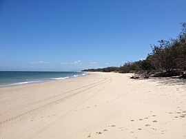
 Woorim Beach | |
 | |
| Coordinates | 26°52′02″S 153°07′36″E / 26.86722°S 153.12667°E |
| Established | 1994 |
| Area | 49 km2 (18.9 sq mi) |
| Visitation | 986,000 (domestic visitors only) (in 2012[1]) |
| Managing authorities | Queensland Parks and Wildlife Service |
| Website | Bribie Island National Park |
| See also | Protected areas of Queensland |
Bribie Island National Park is an Australian national park in the City of Moreton Bay, Queensland,[2] 68 kilometres (42 miles) north of Brisbane. The park covers approximately one third of Bribie Island. The tidal wetlands and areas of water around the islands are protected within the Moreton Bay Marine Park.[3]
Visitors are attracted to the park for angling, boating and the views of the nearby Glass House Mountains.
This is a great place for bird watchers and lovers of spring wildflowers.[4] The average altitude of the terrain is 10 metres.[5]
- ^ "Queensland Parks and Wildlife Service Community Survey 2012" (PDF). Department of Environment, Science and Innovation. December 2012. Retrieved 1 June 2024.
- ^ "Bribie Island National Park (entry 39395)". Queensland Place Names. Queensland Government. Retrieved 25 June 2017.
- ^ "Bribie Island". Sydney Morning Herald. Fairfax Media. 1 January 2009. Retrieved 6 June 2011.
- ^ Science, jurisdiction=Queensland; sector=government; corporateName=Department of Environment and (20 October 2009). "Bribie Island National Park and Recreation Area". Parks and forests | Department of Environment and Science, Queensland. Retrieved 6 February 2022.
{{cite web}}: CS1 maint: multiple names: authors list (link) - ^ "Bribie Island National Park topographic map, elevation, relief". topographic-map.com. Retrieved 7 February 2022.
