Bridgeland-Riverside
Riverside | |
|---|---|
Neighbourhood | |
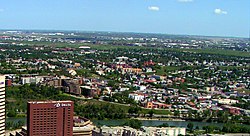
 Bridgeland seen from Calgary Tower | |
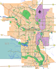
Location of Bridgeland in Calgary | |
| Coordinates: 51°03′17″N 114°02′46″W / 51.05472°N 114.04611°W | |
| Country | Canada |
| Province | Alberta |
| City | Calgary |
| Quadrant | NE |
| Wards | 7, 9 |
| Established | 1908 |
| Annexed | 1910 |
| Government | |
| • Mayor | Jyoti Gondek |
| • Administrative body | Calgary City Council |
| • Councillors | Terry Wong Gian-Carlo Carra |
| Area | |
• Total | 3.2 km2 (1.2 sq mi) |
| Elevation | 1,055 m (3,461 ft) |
| Population (2011)[2] | |
• Total | 5,254 |
| • Median Household Income | $64,201 |
| Postal code | |
| Website | brcacalgary |
Bridgeland-Riverside, formerly known as Bridgeland and Germantown,[3] is a neighbourhood in Calgary, Alberta, Canada, is located northeast of Downtown Calgary. It is bounded to the south by the Bow River, to the east by Deerfoot Trail, to the west by Edmonton Trail and to the north by the community of Renfrew.
The community is primarily residential with a mix of parkside condominiums and single-family houses. Bridgeland contains a variety of restaurants, food markets, retail shopping, offices, financial services, churches and schools. The Wilder Institute/Calgary Zoo, Telus Spark, The Bridges urban renewal development and access to the city's large network of pedestrian pathways (the Bow River pathway) and parks are unique focal points for the community and surrounding region.
Bridgeland borders a natural environment composed of the confluence of the Bow River and Elbow River. Tom Campbell's Hill park lies on the eastern edge of Bridgeland and overlooks the downtown, Bow River and northeastern part of the city.[4] St. Patrick's Island and St. George's Island lie in the southern part of Bridgeland. St. George's Island is home to the Wilder Institute/Calgary Zoo, Canada's second largest zoo.[5]
Bridgeland is the site of the Telus Spark, a $160-million facility that opened on October 29, 2011 and Canada's first purpose-built science centre in more than 25 years.
- ^ "Calgary Elections". City of Calgary. 2017. Retrieved November 12, 2017.
- ^ "Community Social Statistics: Bridgeland/Riverside" (PDF). City of Calgary. 2012. Retrieved 2012-06-21.
- ^ "Bridgeland Riverside Community History".
- ^ Terry Bullick (22 May 2007). Calgary Parks and Pathways: A City's Treasures. Rocky Mountain Books Ltd. p. 191. ISBN 978-1-894739-08-5.
- ^ City of Calgary Calgary Zoo, Botanical Garden & Prehistoric Park

