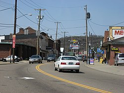
Bridgeport, Ohio | |
|---|---|
 Downtown Bridgeport | |
| Nickname: "Gateway to the West" | |
 Location of Bridgeport, Ohio | |
 Location of Bridgeport in Belmont County | |
| Coordinates: 40°4′20″N 80°44′37″W / 40.07222°N 80.74361°W | |
| Country | United States |
| State | Ohio |
| County | Belmont |
| Township | Pease |
| Government | |
| • Type | Statutory Village |
| • Mayor | Norma Teasdale |
| Area | |
• Total | 1.38 sq mi (3.56 km2) |
| • Land | 1.37 sq mi (3.54 km2) |
| • Water | 0.01 sq mi (0.03 km2) |
| Elevation | 656 ft (200 m) |
| Population (2020) | |
• Total | 1,582 |
• Estimate (2023)[3] | 1,534 |
| • Density | 1,158.13/sq mi (447.01/km2) |
| Time zone | UTC-5 (Eastern (EST)) |
| • Summer (DST) | UTC-4 (EDT) |
| ZIP code | 43912 |
| Area code | 740 |
| FIPS code | 39-08560[4] |
| GNIS feature ID | 1064487[2] |
Bridgeport is a village in eastern Belmont County, Ohio, United States. It lies across the Ohio River from Wheeling, West Virginia, at the mouth of Wheeling Creek and is connected by two bridges to Wheeling Island. The population was 1,582 at the 2020 census. It is part of the Wheeling metropolitan area.
- ^ "ArcGIS REST Services Directory". United States Census Bureau. Retrieved September 20, 2022.
- ^ a b "US Board on Geographic Names". United States Geological Survey. October 25, 2007. Retrieved January 31, 2008.
- ^ "Annual Estimates of the Resident Population for Incorporated Places in Ohio: April 1, 2020 to July 1, 2023". United States Census Bureau. Retrieved June 5, 2024.
- ^ "U.S. Census website". United States Census Bureau. Retrieved January 31, 2008.