Bridgewater | |
|---|---|
Town | |
 A postcard showing King Street | |
| Nickname: Main Street of the South Shore | |
| Coordinates: 44°22′12″N 64°31′12″W / 44.37000°N 64.52000°W | |
| Country | Canada |
| Province | Nova Scotia |
| County | Lunenburg County |
| Founded | 1812 |
| Incorporated | 13 February 1899 |
| Government | |
| • Body | Bridgewater Town Council |
| • Mayor | David Mitchell |
| • CAO | Tammy Crowder |
| • MLA | Becky Druhan (PC) |
| • MP | Rick Perkins (C) |
| Area | |
• Town | 13.61 km2 (5.25 sq mi) |
| • Urban | 13.63 km2 (5.26 sq mi) |
| Elevation (2016)[1] | 22.11 m (72.54 ft) |
| Population | |
• Town | 8,790 |
| • Density | 625.9/km2 (1,621/sq mi) |
| • Urban | 8,790 |
| • Urban density | 640/km2 (1,700/sq mi) |
| Time zone | UTC−4 (AST) |
| • Summer (DST) | UTC−3 (ADT) |
| Postal code | B4V |
| Area code | 902 & 782 |
| Telephone Exchange | 212, 298, 521, 523, 527, 529, 530, 541, 543, 553 |
| Highways | |
| Median Earnings* | $40,123 |
| NTS Map | 21A7 Bridgewater |
| GNBC Code | CAFBR[2] |
| Website | www |
| |
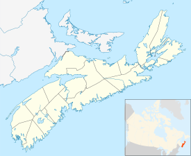
Bridgewater is a town in Lunenburg County, Nova Scotia, Canada, at the navigable limit of the LaHave River. With a 2021 population of 8,790, Bridgewater is the largest town in the South Shore region.
Priding itself as "The Main Street of the South Shore," Bridgewater has long been established as the primary commercial and professional service centre in the southern half of the province. The community boasts a diverse local economy, as well as larger national and international employers.
- ^ a b "Population and dwelling counts, for Canada, provinces and territories, and census subdivisions (municipalities), 2016 and 2011 censuses – 100% data (Nova Scotia)". Statistics Canada. 8 February 2017. Retrieved 12 February 2017.
- ^ "Bridgewater". Geographical Names Data Base. Natural Resources Canada.

