| Brislington Brook | |
|---|---|
 Brislington Brook in St Annes Wood | |
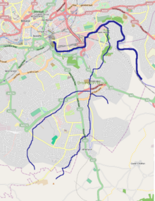
 Diagrammatic map of the Brislington Brook within Bristol | |
| Location | |
| Country | England |
| Region | West Country |
| District | Bristol |
| Physical characteristics | |
| Source | Maes Knoll |
| • location | Whitchurch, Bristol, England |
| • coordinates | 51°23′43″N 2°34′22″W / 51.3952°N 2.5729°W |
| • elevation | 476 ft (145 m) |
| Mouth | Bristol Avon |
• location | St Annes, Bristol, England |
• coordinates | 51°27′14″N 2°32′49″W / 51.4539°N 2.5469°W |
• elevation | 33 ft (10 m) |
| Length | 5 mi (8.0 km), northerly |
| Basin size | 4.6 sq mi (12 km2) |
| Basin features | |
| River system | Bristol Avon |
Brislington Brook is a short, 5 miles (8.0 km) long tributary of the Bristol Avon, rising on the northern slopes of Maes Knoll on the southern boundary of the city of Bristol, England. The stream has been badly affected by pollution but improvements have been made in the latter part of the twentieth century, and some wildlife is supported. St Anne's Well near the northern end of the brook was a major pilgrimage site for Christians in the Middle Ages.