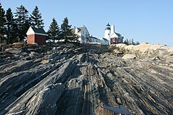
Bristol, Maine | |
|---|---|
 | |
 Location in Lincoln County and the state of Maine. | |
| Coordinates: 43°55′29″N 69°29′44″W / 43.92472°N 69.49556°W | |
| Country | United States |
| State | Maine |
| County | Lincoln |
| Incorporated | 1765 |
| Area | |
| • Total | 78.23 sq mi (202.61 km2) |
| • Land | 33.99 sq mi (88.03 km2) |
| • Water | 44.24 sq mi (114.58 km2) |
| Elevation | 121 ft (37 m) |
| Population (2020) | |
| • Total | 2,834 |
| • Density | 83/sq mi (32.2/km2) |
| Time zone | UTC-5 (Eastern (EST)) |
| • Summer (DST) | UTC-4 (EDT) |
| ZIP code | 04539 Bristol Mills, 04551 Chamberlain, 04554 New Harbor, 04558 Pemaquid, 04564 Round Pond |
| Area code | 207 |
| FIPS code | 23-07485 |
| GNIS feature ID | 0582369 |
| Website | www.bristolmaine.org |
Bristol, known from 1632 to 1765 as Pemaquid (/ˈpɛməkwɪd/; today a village within the town), is a town in Lincoln County, Maine, United States. The population was 2,834 at the 2020 census.[2] A fishing and resort area, Bristol includes the villages of New Harbor, Pemaquid, Round Pond, Bristol Mills and Chamberlain. It includes the Pemaquid Archeological Site, a U.S. National Historic Landmark. During the 17th and early 18th century, New France defined the Kennebec River as the southern boundary of Acadia, which put Bristol within Acadia.[3]
- ^ Cite error: The named reference
Gazetteer fileswas invoked but never defined (see the help page). - ^ "Census - Geography Profile: Bristol town, Lincoln County, Maine". Retrieved January 16, 2022.
- ^ The French declared the southern boundary of Acadia to be the Kennebec River in 1687, which meant the French considered Bristol was considered part of Acadia. (See Griffiths, N.E.S. (2005). From Migrant to Acadian: A North American Border People, 1604-1755. McGill-Queen's University Press. p. 61. ISBN 978-0-7735-2699-0. and Campbell, William Edgar (2005). The Road to Canada: The Grand Communications Route from Saint John to Quebec. Goose Lane Editions. p. 21. ISBN 978-0-86492-426-1.). The village, however, was English and the New Englanders considered it the northern boundary (See Benjamin Church. The History of King Phillips War. 1825. p. 181).