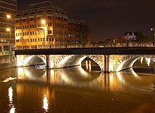
Bristol Bridge | |
|---|---|
 Bristol Bridge from Welsh Back | |
| Coordinates | 51°27′13″N 2°35′29″W / 51.4536°N 2.5913°W |
| Carries | Motor vehicles, pedestrians |
| Crosses | Bristol Harbour / River Avon |
| Locale | Bristol |
| Maintained by | Bristol City Council |
| History | |
| Opened | 1768 |
| Location | |
 | |

Bristol Bridge is a bridge over the floating harbour in Bristol, England. The floating harbour was constructed on the original course of the River Avon, and there has been a bridge on the site since long before the harbour was created by impounding the river in 1809. The current bridge was completed in 1768 and is a Grade II listed building.[1]
Bristol Bridge is the furthest downstream of the fixed bridges across the harbour, and marks the limit of navigation for any vessel that is unable to pass beneath its arches. Downstream from the bridge the harbour is lined by wharves and warehouses, with Welsh Back to the west and Redcliffe Back to the east. Upstream, the land to the west is occupied by Castle Park, created on an area destroyed by bombing during the Second World War, whilst the opposite bank is occupied by the former Georges Bristol Brewery, now redeveloped as Finzels Reach.[2]
- ^ Historic England. "Bristol Bridge (1204252)". National Heritage List for England. Retrieved 5 January 2022.
- ^ "The Inner Harbour". Bristol Floating Harbour. Archived from the original on 4 January 2022. Retrieved 4 January 2022.