| Broadback River | |
|---|---|
 Tupatukasi Waterfall, Broadback River | |
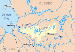
 Broadback River basin in yellow | |
| Location | |
| Country | Canada |
| Province | Quebec |
| Region | Jamésie |
| Physical characteristics | |
| Source | Lac Frotet |
| • location | 95 km north of Chibougamau, Nord-du-Québec |
| • coordinates | 50°46′0″N 74°39′20″W / 50.76667°N 74.65556°W |
| • elevation | 380 m (1,250 ft) |
| Mouth | Rupert Bay off James Bay |
• location | 17 km south of Waskaganish, Nord-du-Québec |
• coordinates | 51°21′20″N 78°52′00″W / 51.35556°N 78.86667°W |
• elevation | 0 m (0 ft) |
| Length | 450 km (280 mi)[1] |
| Basin size | 20,800 km2 (8,000 sq mi)[1] |
| Discharge | |
| • average | 350 m3/s (12,000 cu ft/s)[1] |
| Basin features | |
| Tributaries | |
| • left |
|
| • right |
|
The Broadback River (French: Rivière Broadback) (In Cree: Chistamiskau Sipi[2]) is a river in northern Quebec, Canada. It drains into Rupert Bay (a smaller bay at the south end of James Bay), just south of the Rupert River and Cree community Waskaganish. The major lake on the river's course is Lake Evans.
The river is a popular canoe-tripping destination.[3]
- ^ a b c Atlas of Canada Archived February 2, 2007, at the Wayback Machine
- ^ "Banque de noms de lieux du Québec: Reference number 8435". toponymie.gouv.qc.ca (in French). Commission de toponymie du Québec.
- ^ Lester Kovac. "Broadback 2005".