| Broken Top | |
|---|---|
 | |
| Highest point | |
| Elevation | 9,177 ft (2,797 m) NAVD 88[1] |
| Coordinates | 44°04′58″N 121°41′59″W / 44.0828931°N 121.6997595°W[2] |
| Geography | |
 | |
| Location | Deschutes County, Oregon, U.S. |
| Parent range | Cascade Range |
| Topo map | USGS Broken Top |
| Geology | |
| Rock age | Pleistocene |
| Mountain type | Stratovolcano |
| Volcanic arc | Cascade Volcanic Arc |
| Last eruption | About 100,000 years ago[3] |
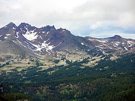
Broken Top is a glacially eroded complex stratovolcano. It lies in the Cascade Volcanic Arc, part of the extensive Cascade Range in the U.S. state of Oregon. Located southeast of the Three Sisters peaks, the volcano, residing within the Three Sisters Wilderness,[4] is 20 miles (32 km) west of Bend, Oregon in Deschutes County. Eruptive activity stopped roughly 100,000 years ago, and erosion by glaciers has since reduced the volcano's cone to where its contents are exposed. There are two named glaciers on the peak, Bend and Crook Glacier.
Diverse species of flora and fauna inhabit the area, which is subject to frequent snowfall, occasional rain, and extreme temperature variation between seasons. Broken Top and its surrounding area constitute popular destinations for hiking, climbing, and scrambling.
- ^ Hildreth 2007, p. 7.
- ^ "Broken Top". Geographic Names Information System. United States Geological Survey, United States Department of the Interior. Retrieved 2008-03-31.
- ^ "Broken Top Volcano". Deschutes & Ochoco National Forests. USDA Forest Service. 2003-11-26. Archived from the original on 2010-11-09. Retrieved 2008-03-18.
- ^ "Three Sisters Wilderness". Willamette National Forest. United States Forest Service. 2004-07-29. Archived from the original on 2010-08-06. Retrieved 2008-05-18.