Brookeville, Maryland | |
|---|---|
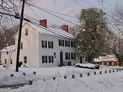
 The Madison House in February 2006. It was built around 1800 and originally owned by Caleb Bentley. The house provided refuge for President James Madison, on August 26, 1814, after the British burned Washington, D.C., during the War of 1812. | |
| Motto: "United States Capital For A Day August 26, 1814"[1] | |
 Location of Brookeville in Montgomery County, Maryland, Inset: Location of Montgomery County in Maryland. | |
| Coordinates: 39°10′51″N 77°03′33″W / 39.18083°N 77.05917°W | |
| Country | United States |
| State | Maryland |
| County | Montgomery |
| Settled | 1794[1] |
| Incorporated | 1808[1] |
| Area | |
• Total | 0.14 sq mi (0.36 km2) |
| • Land | 0.14 sq mi (0.36 km2) |
| • Water | 0.00 sq mi (0.00 km2) |
| Elevation | 433 ft (132 m) |
| Population | |
• Total | 166 |
| • Density | 1,185.71/sq mi (459.09/km2) |
| • Demonym | Brookevillian |
| Time zone | UTC-5 (Eastern (EST)) |
| • Summer (DST) | UTC-4 (EDT) |
| ZIP Code | 20833 |
| Area code(s) | 301, 240 |
| FIPS code | 24-10225 |
| GNIS feature ID | 2390755[3] |
| Website | townofbrookevillemd |
Brookeville is a town in Montgomery County, Maryland, located 20 km (12 mi) north of Washington, D.C., and 2 km (1.2 mi) north of Olney. Brookeville was settled by Quakers late in the 18th century and was incorporated as a town in 1808. Historically a farming town, Brookeville is now at the northern edge of the densely developed Washington suburbs. The population was 166 at the 2020 census.[4]
Brookeville is notable as the "United States Capital for a Day": when British troops burned Washington, D.C., during the War of 1812, President James Madison sought refuge in the town on August 26, 1814. During the American Civil War, Brookeville, along with nearby Sandy Spring, was a stop on the Underground Railroad.
- ^ a b c "The Town of Brookeville Maryland". The Town of Brookeville Maryland. Retrieved September 29, 2012.
- ^ "2022 U.S. Gazetteer Files: Maryland". United States Census Bureau. Retrieved May 26, 2023.
- ^ a b U.S. Geological Survey Geographic Names Information System: Brookeville, Maryland
- ^ a b "P1. Race – Brookeville town, Maryland: 2020 DEC Redistricting Data (PL 94-171)". U.S. Census Bureau. Retrieved May 26, 2023.