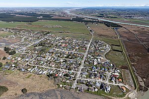
Brooklands | |
|---|---|
 Brooklands just after the 2010 Canterbury earthquake | |
 | |
| Coordinates: 43°24′14″S 172°41′45″E / 43.40389°S 172.69583°E | |
| Country | New Zealand |
| City | Christchurch |
| Local authority | Christchurch City Council |
| Electoral ward | Coastal |
| Community board | Waitai Coastal-Burwood-Linwood |
| Area | |
| • Land | 308 ha (761 acres) |
| Population (2018 Census)[2] | |
| • Total | 129 |
| Kaiapoi | (Waimakariri River) | |
|
|
(Brooklands Lagoon) | |
| Chaneys | (Bottle Lake Forest) |
Brooklands is the northernmost suburb of Christchurch, New Zealand. The settlement was built on former swamp land adjacent to Brooklands Lagoon, which forms part of the Waimakariri River mouth. The land damage sustained in the 2010 and 2011 Christchurch earthquakes and subsequent Red Zone classification resulted in the buyout and demolition of nearly all properties in Brooklands, effectively wiping the suburb off the map.[3]