Brookston | |
|---|---|
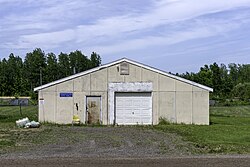
 Brookston City Hall | |
 Location of the city of Brookston within Saint Louis County, Minnesota | |
| Coordinates: 46°51′57″N 92°36′12″W / 46.86583°N 92.60333°W | |
| Country | United States |
| State | Minnesota |
| County | Saint Louis |
| Founded | 1905 |
| Incorporated | April 13, 1907 |
| Government | |
| • Mayor | Brenda Hansen |
| Area | |
• Total | 0.55 sq mi (1.42 km2) |
| • Land | 0.55 sq mi (1.42 km2) |
| • Water | 0.00 sq mi (0.00 km2) |
| Elevation | 1,230 ft (370 m) |
| Population | |
• Total | 118 |
• Estimate (2021)[4] | 116 |
| • Density | 215.72/sq mi (83.25/km2) |
| Time zone | UTC-6 (CST) |
| • Summer (DST) | UTC-5 (CDT) |
| ZIP code | 55711 |
| Area code | 218 |
| FIPS code | 27-08056[5] |
| GNIS feature ID | 0660884[2] |
Brookston is a city in Saint Louis County, Minnesota, United States; located along the Saint Louis River, opposite the mouth of the Artichoke River. The population was 118 at the 2020 census.[3]
Brookston is located 27 miles west of the city of Duluth and 17 miles northwest of the city of Cloquet.
U.S. Highway 2 and Saint Louis County Road 31 (CR 31) are two of the main routes in Brookston.
The city of Brookston is located within Culver Township geographically but is a separate entity. Brookston is politically independent of the township.
Brookston is located on the northern edge of the Fond du Lac Indian Reservation. It is one of three administrative centers of the reservation.
- ^ "2020 U.S. Gazetteer Files". United States Census Bureau. Retrieved July 24, 2022.
- ^ a b U.S. Geological Survey Geographic Names Information System: Brookston, Minnesota
- ^ a b "Explore Census Data". United States Census Bureau. Retrieved July 31, 2022.
- ^ Cite error: The named reference
USCensusEst2021was invoked but never defined (see the help page). - ^ "U.S. Census website". United States Census Bureau. Retrieved January 31, 2008.