Brown's Farm | |
|---|---|
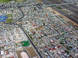
An aerial view of the central southern part of Browns Farm just north of the train station. | |
| Coordinates: 34°0′S 18°34′E / 34.000°S 18.567°E | |
| Country | South Africa |
| Province | Western Cape |
| Municipality | City of Cape Town |
| Sub Place | Cape Town |
| Area | |
| • Total | 3.39 km2 (1.31 sq mi) |
| Population (2011)[1] | |
| • Total | 71,518 |
| • Density | 21,000/km2 (55,000/sq mi) |
| Time zone | UTC+2 (SAST) |
| Postal code (street) | 7750 |
| PO box | 7781 |
| Area code | 021 |
The Brown's Farm area is a neighborhood located within the Philippi area of Cape Town's Cape Flats region, in the Western Cape province of South Africa. The urban area is densely populated and contains many informal homes. The 2011 national census recorded 71,518 residents living in the area.
- ^ a b c "Census 2011".


