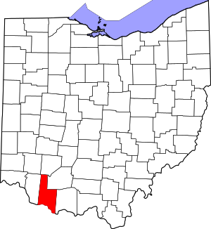
Brown County | |
|---|---|
 | |
 Location within the U.S. state of Ohio | |
 Ohio's location within the U.S. | |
| Coordinates: 38°56′N 83°52′W / 38.93°N 83.87°W | |
| Country | |
| State | |
| Founded | March 1, 1818 |
| Named for | General Jacob Brown |
| Seat | Georgetown |
| Largest village | Georgetown |
| Area | |
• Total | 493 sq mi (1,280 km2) |
| • Land | 490 sq mi (1,300 km2) |
| • Water | 3.4 sq mi (9 km2) 0.7% |
| Population (2020) | |
• Total | 43,676 |
| • Density | 89/sq mi (34/km2) |
| Time zone | UTC−5 (Eastern) |
| • Summer (DST) | UTC−4 (EDT) |
| Congressional district | 2nd |
| Website | www |
Brown County is a county in the U.S. state of Ohio. As of the 2020 United States Census, the population was 43,676.[1] The county seat is Georgetown.[2] The county was created in 1818[3] and is named for Major General Jacob Brown, an officer in the War of 1812 who was wounded at the Battle of Lundy's Lane.[4] Brown County is part of the Cincinnati-Middletown, OH-KY-IN Metropolitan Statistical Area.
- ^ 2020 census
- ^ "Find a County". National Association of Counties. Archived from the original on May 31, 2011. Retrieved June 7, 2011.
- ^ "Ohio: Individual County Chronologies". Ohio Atlas of Historical County Boundaries. The Newberry Library. 2007. Archived from the original on April 6, 2016. Retrieved February 12, 2015.
- ^ Taylor, William Alexander (1899). Ohio Statesmen and Annals of Progress. Press of the Westbote Company. p. 243.

