Brownstown, Indiana | |
|---|---|
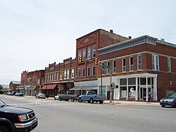
 Historic Downtown Main Street | |
 Location of Brownstown in Jackson County, Indiana. | |
| Coordinates: 38°52′40″N 86°02′48″W / 38.87778°N 86.04667°W | |
| Country | United States |
| State | Indiana |
| County | Jackson |
| Township | Brownstown |
| Area | |
• Total | 1.62 sq mi (4.21 km2) |
| • Land | 1.62 sq mi (4.19 km2) |
| • Water | 0.01 sq mi (0.01 km2) |
| Elevation | 656 ft (200 m) |
| Population (2020) | |
• Total | 3,025 |
| • Density | 1,868.44/sq mi (721.59/km2) |
| Time zone | UTC-5 (EST) |
| • Summer (DST) | UTC-5 (EST) |
| ZIP code | 47220 |
| Area code | 812 |
| FIPS code | 18-08470[3] |
| GNIS feature ID | 2396612[2] |
| Website | https://www.explorebrownstown.com/ |
Brownstown is a town within Brownstown Township and the county seat of Jackson County, Indiana, United States.[4] The population was 2,947 at the 2010 census. It was named for Jacob Brown, a general of the War of 1812.[5]
- ^ "2020 U.S. Gazetteer Files". United States Census Bureau. Retrieved March 16, 2022.
- ^ a b U.S. Geological Survey Geographic Names Information System: Brownstown, Indiana
- ^ "U.S. Census website". United States Census Bureau. Retrieved January 31, 2008.
- ^ "Find a County". National Association of Counties. Archived from the original on May 31, 2011. Retrieved June 7, 2011.
- ^ History of Jackson County, Indiana: From the Earliest Time to the Present, with Biographical Sketches, Notes, Etc., Together with an Extended History of the Northwest, the Indiana Territory and the State of Indiana. Unigraphic. 1886. p. 362.