Brownstown Township, Michigan | |
|---|---|
| Charter Township of Brownstown | |
 Brownstown Charter Township Offices | |
| Motto: "Where The Future Looks Brighter"[1] | |
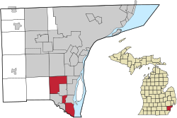
 Location within Wayne County | |
| Coordinates: 42°07′34″N 83°15′26″W / 42.12611°N 83.25722°W | |
| Country | |
| State | |
| County | |
| Established | 1827 |
| Government | |
| • Supervisor | Edward Smith |
| • Clerk | Rodney Sgarbossa |
| Area | |
| 30.64 sq mi (79.36 km2) | |
| • Land | 22.19 sq mi (57.47 km2) |
| • Water | 8.45 sq mi (21.89 km2) |
| Elevation | 584 ft (178 m) |
| Population (2020) | |
| 33,194 | |
| • Density | 1,100/sq mi (420/km2) |
| • Metro | 3,776,890 (Metro Detroit) |
| Time zone | UTC-5 (EST) |
| • Summer (DST) | UTC-4 (EDT) |
| ZIP code(s) | |
| Area code | 734 |
| FIPS code | 26-11220[2] |
| GNIS feature ID | 1625993[3] |
| Website | Official website |
Brownstown Charter Township is a charter township in Wayne County in the U.S. state of Michigan. Its population was 33,194 at the 2020 census.[4] Brownstown was established in 1827, a decade prior to Michigan's admission to the Union.
Brownstown has three separate but connected segments due to the incorporation of the cities of Flat Rock, Rockwood, and Woodhaven in the early 1960s.[5]
- ^ "The Charter Township of Brownstown, Michigan". The Charter Township of Brownstown, Michigan. Retrieved August 24, 2012.
- ^ "U.S. Census website". United States Census Bureau. Retrieved 2008-01-31.
- ^ U.S. Geological Survey Geographic Names Information System: Brownstown Charter Township, Michigan
- ^ "Explore Census Data". data.census.gov. Retrieved 2024-04-20.
- ^ History of Woodhaven Archived July 5, 2007, at the Wayback Machine


