Brownsville, Kentucky | |
|---|---|
 Aerial photograph of Brownsville | |
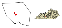
 Location of Brownsville in Edmonson County, Kentucky. | |
| Coordinates: 37°11′28″N 86°15′40″W / 37.19111°N 86.26111°W | |
| Country | United States |
| State | Kentucky |
| County | Edmonson |
| Established | 1826[1] |
| Government | |
| Area | |
| • Total | 2.62 sq mi (6.78 km2) |
| • Land | 2.61 sq mi (6.77 km2) |
| • Water | 0.01 sq mi (0.02 km2) |
| Elevation | 541 ft (165 m) |
| Population (2020) | |
| • Total | 875 |
| • Density | 334.99/sq mi (129.33/km2) |
| Time zone | UTC-6 (Central (CST)) |
| • Summer (DST) | UTC-5 (CDT) |
| ZIP code | 42210 |
| Area code(s) | 270 & 364 |
| FIPS code | 21-10324 |
| GNIS feature ID | 0488045[3] |
Brownsville is a home rule-class city in Edmonson County, Kentucky, in the United States. It is the county seat and is a certified Kentucky Trail Town.[4] The population was 836 at the time of the 2010 census,[5] down from 921 at the 2000 census. It is included in the Bowling Green metropolitan area.[6] It is just outside Mammoth Cave National Park.[7]
- ^ Cite error: The named reference
estdatewas invoked but never defined (see the help page). - ^ "2020 U.S. Gazetteer Files". United States Census Bureau. Retrieved March 18, 2022.
- ^ a b U.S. Geological Survey Geographic Names Information System: Brownsville, Kentucky
- ^ "Find a County". National Association of Counties. Archived from the original on May 31, 2011. Retrieved June 7, 2011.
- ^ "Geographic Identifiers: 2010 Demographic Profile Data (G001): Brownsville city, Kentucky". American Factfinder. U.S. Census Bureau. Archived from the original on February 13, 2020. Retrieved January 29, 2016.
- ^ Management and Budget, Office of (November 20, 2008). "OMB BULLETIN NO. 09-01" (PDF). the President, Executive Office of. Retrieved April 15, 2010.
- ^ Service, National Park. "Mammoth Cave National Park Map" (PDF). Retrieved April 15, 2010.