| Bruce Peninsula National Park | |
|---|---|
| Parc national de la Péninsule-Bruce | |
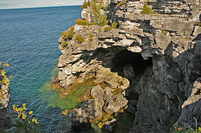
 The Grotto | |
| Location | Ontario, Canada |
| Nearest city | Tobermory |
| Coordinates | 45°14′20″N 81°36′51″W / 45.23889°N 81.61417°W |
| Area | 154 km2 (59 sq mi) |
| Established | 1987 |
| Visitors | 460,435 (in 2022–23[1]) |
| Governing body | Parks Canada |
 | |
Bruce Peninsula National Park is a national park on the Bruce Peninsula in Ontario, Canada. Located on a part of the Niagara Escarpment, the park comprises 156 square kilometres and is one of the largest protected areas in southern Ontario, forming the core of UNESCO's Niagara Escarpment World Biosphere Reserve.[2] It was established in 1987 to protect the rock formations and shoreline of the Niagara Escarpment.[3] The park offers opportunities for many outdoor activities, including hiking, camping, boating, and bird watching. The park has trails ranging in difficulty from easy to expert, and connects to the Bruce Trail. Bruce Peninsula National Park is known for its crystal clear blue waters, cobblestone beaches, rocky cliffs and karst formations.[3]
The park is open year-round[3] and offers visitors vistas to view either the sunrise or sunset, the rocks of the Niagara Escarpment, and the wildlife, which includes black bear, many species of birds, wild orchids, massasauga rattlesnake, and much more.
The park was the subject of a short film in 2011's National Parks Project, directed by Daniel Cockburn and scored by John K. Samson, Christine Fellows and Sandro Perri.
The Bruce Peninsula National Park has a weather and tourist information station CBPS-FM which operates at 90.7 FM. The station was launched in the mid-1990s.[4]

3miles
Bay
Marine Park
National Park
- ^ Canada, Parks. "Parks Canada attendance 2022_23 - Parks Canada attendance 2022_23 - Open Government Portal". open.canada.ca. Retrieved 2024-05-07.
- ^ [Canada Newswire; Parks Canada hosts opening ceremony for a new visitor centre at Fathom Five National Marine Park of Canada and Bruce Peninsula National Park of Canada; August 16, 2006]
- ^ a b c National Geographic Guide to the National Parks of Canada (Second ed.). Washington, D.C.: National Geographic Partners. 2017. pp. 142–147.
- ^ Decision CRTC 94-613, New low-power FM radio station at Bruce Peninsula National Park, CRTC, August 15, 1994
- ^ "Bruce Peninsula National Park: Parks map". Parks Canada. Retrieved June 21, 2018.


