Brumley, Missouri | |
|---|---|
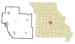
 Location in Miller County and the state of Missouri | |
| Coordinates: 38°05′17″N 92°29′04″W / 38.08806°N 92.48444°W[1] | |
| Country | United States |
| State | Missouri |
| County | Miller |
| Area | |
| • Total | 0.55 sq mi (1.43 km2) |
| • Land | 0.55 sq mi (1.43 km2) |
| • Water | 0.00 sq mi (0.00 km2) |
| Elevation | 820 ft (250 m) |
| Population | |
| • Total | 69 |
| • Density | 125.23/sq mi (48.35/km2) |
| Time zone | UTC-6 (Central (CST)) |
| • Summer (DST) | UTC-5 (CDT) |
| ZIP code | 65017 |
| Area code | 573 |
| FIPS code | 29-08974[4] |
| GNIS feature ID | 2396614[1] |
Brumley is a town in Miller County, Missouri, United States.[1] The population was 69 at the 2020 census,[3] down from 91 in 2010.
- ^ a b c d U.S. Geological Survey Geographic Names Information System: Brumley, Missouri
- ^ "ArcGIS REST Services Directory". United States Census Bureau. Retrieved August 28, 2022.
- ^ a b "P1. Race – Brumley town, Missouri: 2020 DEC Redistricting Data (PL 94-171)". U.S. Census Bureau. Retrieved April 17, 2024.
- ^ "U.S. Census website". United States Census Bureau. Retrieved January 31, 2008.