Bucketts Way | |
|---|---|
 | |
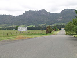
| The Bucketts Range from Bucketts Way | |
| Coordinates | |
| General information | |
| Type | Rural road |
| Length | 151 km (94 mi)[1] |
| Gazetted | August 1928 (as Main Road 10)[2] July 1952 (as Trunk Road 90)[3] |
| Route number(s) | |
| Major junctions | |
| North end | Manning River Drive Purfleet, New South Wales |
| Thunderbolts Way | |
| South end | Twelve Mile Creek, New South Wales |
| Location(s) | |
| Major settlements | Tinonee, Gloucester, Stroud |
| ---- | |
(The) Bucketts Way is a 151-kilometre (94 mi)[1] rural road that links Gloucester to Taree and Raymond Terrace, in New South Wales, Australia. A former alignment of Pacific Highway, it was later named after the Bucketts Mountains, a prominent mountain range near Gloucester. The entire route is designated as Tourist Route 2.[4]
- ^ a b "The Bucketts Way" (Map). Google Maps. Retrieved 7 December 2022.
- ^ "Main Roads Act, 1924-1927". Government Gazette of the State of New South Wales. No. 110. National Library of Australia. 17 August 1928. pp. 3814–20. Retrieved 1 August 2022.
- ^ "Main Roads Act, 1924-1951". Government Gazette of the State of New South Wales. No. 167. National Library of Australia. 22 August 1952. p. 3044. Archived from the original on 19 September 2022. Retrieved 7 December 2022.
- ^ "Tourist Drive 2 - Bucketts Way". Destination NSW. Government of New South Wales. Retrieved 10 December 2021.
