| Buckland | |
|---|---|
 St Mary the Virgin parish church | |
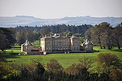
 Buckland House with surrounding countryside | |
Location within Oxfordshire | |
| Area | 18.23 km2 (7.04 sq mi) |
| Population | 588 (parish, including Gainfield) (2011 Census) |
| • Density | 32/km2 (83/sq mi) |
| OS grid reference | SU3498 |
| Civil parish |
|
| District | |
| Shire county | |
| Region | |
| Country | England |
| Sovereign state | United Kingdom |
| Post town | Faringdon |
| Postcode district | SN7 |
| Dialling code | 01367 |
| Police | Thames Valley |
| Fire | Oxfordshire |
| Ambulance | South Central |
| UK Parliament | |
| Website | Buckland, Oxfordshire |
Buckland is a village and large civil parish about 4 miles (6.4 km) northeast of Faringdon[1] in the Vale of White Horse District. Buckland was part of Berkshire until the 1974 boundary changes transferred it to Oxfordshire. The 2011 Census recorded the parish's population as 588.[2] Outside the village the civil parish includes the small settlements of Carswell and Barcote to the west, Buckland Marsh to the north, and the modern development of Gainfield on the southern boundary.
- ^ Wilson 1870–72[page needed]
- ^ UK Census (2011). "Local Area Report – Buckland Parish (1170217860)". Nomis. Office for National Statistics. Retrieved 29 August 2018.
