| Bud Dajo | |
|---|---|
| |
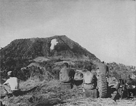
 Bud Dajo photographed in 1945 | |
| Highest point | |
| Elevation | 620 m (2,030 ft)[1] |
| Prominence | 620 m (2,030 ft) |
| Listing | Mountains of the Philippines |
| Coordinates | 6°0′48″N 121°03′24″E / 6.01333°N 121.05667°E[1] |
| Geography | |
 | |
| Location | Sulu, Philippines |
| Geology | |
| Mountain type | Cinder cone |
| Volcanic arc | Zamboanga-Sulu Arc |
| Last eruption | Unknown |
Bud Dajo (Tausug: Būd Dahu; Spanish: Monte Dajó), is a cinder cone and the second highest point (+600m) in Sulu, a province of the Philippines in the Sulu Archipelago. It is one of the cinder cones that make up the island of Jolo and part of the Jolo Volcanic Group.[2] The extinct volcano is located 8 kilometres (5.0 mi) southeast from the town of Jolo in Sulu. The mountain and adjacent lands were declared as Mount Dajo National Park in 1938.[3] It is a sacred mountain for the locals, and the Tausug people at-large, as well as nearby ethnic groups.[4]
- ^ a b "Jolo". Global Volcanism Program. Smithsonian Institution. Retrieved 2006-06-12.
- ^ "Synonyms and subfeatures - Jolo". Global Volcanism Program. Retrieved on 2011-09-24.
- ^ Cite error: The named reference
Birdlifewas invoked but never defined (see the help page). - ^ Pershing and the Disarmament of the Moros. Pacific Historical Review. Vol. 31, No. 3 (Aug., 1962), pp. 241-256. University of California Press.

