Bueng Khong Long
บึงโขงหลง | |
|---|---|
 Lake near Bueng Khong Long village | |
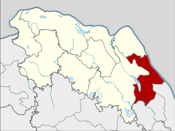
 District location in Bueng Kan province | |
| Coordinates: 17°58′0″N 104°2′42″E / 17.96667°N 104.04500°E | |
| Country | Thailand |
| Province | Bueng Kan |
| Seat | Bueng Khong Long |
| Subdistricts | 4 |
| Mubans | 51 |
| District established | 1986 |
| Area | |
| • Total | 398.152 km2 (153.727 sq mi) |
| Population (2015) | |
| • Total | 37,300 |
| • Density | 87.2/km2 (226/sq mi) |
| Time zone | UTC+7 (ICT) |
| Postal code | 38220 |
| Geocode | 3806 |
Bueng Khong Long (Thai: บึงโขงหลง, pronounced [bɯ̄ŋ kʰǒːŋ lǒŋ]) is a district (amphoe) of Bueng Kan province, northeastern Thailand.
Both this district and its Bueng Khong Long subdistrict are named after a reservoir south of Bueng Khong Long town. The reservoir was created in the 1980s under a royal initiative by the late-King Bhumibol Adulyadej to provide irrigation for farmers as well as to enhance biodiversity. The lake's wetlands are an important stopover point for migrating birds, and also a spawning ground for fish. Fish are a key protein source for locals.[1]
- ^ "Villagers work to protect the water and key wetlands in Bueng Khong Long reservoir". The Nation. 1 January 2017. Retrieved 1 January 2017.