Buldan | |
|---|---|
District and municipality | |
 | |
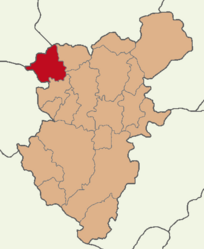
 Map showing Buldan District in Denizli Province | |
| Coordinates: 38°2′42″N 28°49′50″E / 38.04500°N 28.83056°E | |
| Country | Turkey |
| Province | Denizli |
| Government | |
| • Mayor | Mehmet Ali Orpak (CHP) |
Area | 523 km2 (202 sq mi) |
| Population (2022)[1] | 26,630 |
| • Density | 51/km2 (130/sq mi) |
| Time zone | UTC+3 (TRT) |
| Postal code | 20400 |
| Area code | 0258 |
| Website | www |
Buldan is a municipality and district of Denizli Province, Turkey.[2] Its area is 523 km2,[3] and its population is 26,630 (2022).[1] Buldan district area neighbors to the east and the south three other districts of the same province, namely Güney, Pamukkale and Sarayköy, and to the west by the areas of three districts of Aydın Province, Buharkent, Kuyucak and Karacasu, and to the northwest by Sarıgöl district of Manisa Province.
The town of Buldan is located at a distance of 46 km (29 mi) from the province seat of Denizli and lies at an altitude of 690 meters. It extends along a pretty hilltop area, with hillsides covered with pomegranates, figs, vines and blackberries. There are lovely views from the high meadows. Kestane Deresi (Chestnut Stream) is a favourite popular excursion spot situated in the upper parts of the main town.
Buldan's depending township of Yenicekent is the site of ancient Tripolis of Phrygia.
- ^ a b Cite error: The named reference
tuikwas invoked but never defined (see the help page). - ^ Büyükşehir İlçe Belediyesi, Turkey Civil Administration Departments Inventory. Retrieved 12 July 2023.
- ^ "İl ve İlçe Yüz ölçümleri". General Directorate of Mapping. Retrieved 12 July 2023.

