| Bullengarook Victoria | |||||||||||||||
|---|---|---|---|---|---|---|---|---|---|---|---|---|---|---|---|
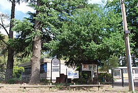
 Former Primary school | |||||||||||||||
| Coordinates | 37°31′S 144°29′E / 37.517°S 144.483°E | ||||||||||||||
| Population | 645 (2016 census)[1] | ||||||||||||||
| Postcode(s) | 3437 | ||||||||||||||
| Elevation | 484 m (1,588 ft) | ||||||||||||||
| Location |
| ||||||||||||||
| LGA(s) | Shire of Macedon Ranges | ||||||||||||||
| State electorate(s) | Macedon | ||||||||||||||
| Federal division(s) | McEwen | ||||||||||||||
| |||||||||||||||
Bullengarook /bəˈlʌŋɡərʊk/ is a locality in Victoria, Australia. The locality is centred on Bacchus Marsh Road, 14 kilometres (9 mi) west of Gisborne and 19 km north of Bacchus Marsh. Bullengarook is in the Shire of Macedon Ranges local government area. At the 2011 Census, Bullengarook and the surrounding area had a population of 603.[2] Mount Bullengarook, the Lerderderg State Park and the headwaters of Coimadai Creek are found to the south of the township.[3]
- ^ Australian Bureau of Statistics (27 June 2017). "Bullengarook (State Suburb)". 2016 Census QuickStats. Retrieved 3 September 2021.
- ^ Australian Bureau of Statistics (25 October 2007). "Bullengarook (State Suburb)". 2006 Census QuickStats. Retrieved 30 March 2008.
- ^ "Bullengarook". Victorian Places. Retrieved 31 March 2019.
