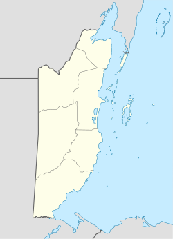
Bullet Tree Falls | |
|---|---|
 Aerial view of the main road in Bullet Tree Falls | |
| Coordinates: 17°10′05″N 89°06′40″W / 17.168°N 89.111°W | |
| Country | |
| District | Cayo District |
| Constituency | Cayo North |
| Elevation | 69 m (226 ft) |
| Population (2010) | |
| • Total | 2,124[1] |
| Time zone | UTC-6 (Central) |
| Climate | Am |
Bullet Tree Falls is a village located along the Mopan River in Cayo District, Belize. It lies approximately five kilometers (three miles) northwest of San Ignacio.[2][3] According to the 2010 census, Bullet Tree Falls has a population of 2,124 people in 426 households.[1] The population consists mainly of Spanish-speaking mestizos, along with a smaller number of Maya and Creoles.[2][3][4] The village is governed by a seven-person village council.[5]
- ^ a b "Belize Population and Housing Census: 2010 Country Report" (PDF). Statistical Institute of Belize. Archived from the original (PDF) on 27 January 2016. Retrieved 25 July 2015.
- ^ a b Pridgeon, Elizabeth (19 February 2010). "Bullet Tree Falls". The Belize Times. Archived from the original on 26 May 2011.
- ^ a b Eltringham, Peter; Fisher, John; Stewart, Iain (2001). The Rough Guide to the Maya World: Guatemala, Belize, Southern Mexico, Honduras, El Salvador. London: Rough Guides. p. 269. ISBN 1858287421.
- ^ Gordon, Andrew (28 February 2020). "Rastafarianism in Bullet Tree Falls, Belize: Exploring the Effects of International Trends". Societies. 10 (1): 1–16. doi:10.3390/soc10010024.
- ^ "Village Council Election Results: Bullet Tree, Cayo District" (PDF). Elections and Boundaries Department, Government of Belize. July 29, 2019. Archived from the original (PDF) on September 25, 2019. Retrieved September 25, 2019.

