| Bumbungan River Pagsanjan River | |
|---|---|
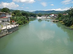
 The river in Pagsanjan | |
Bumbungan River mouth | |
| Native name | Ilog Bumbungan (Tagalog) |
| Location | |
| Country | Philippines |
| Region | Calabarzon |
| Province | Laguna |
| City/municipality | |
| Physical characteristics | |
| Source | |
| • location | Sierra Madre mountains |
| • elevation | about 430 metres (1,400 ft) |
| Mouth | At the easternmost lobe of Laguna de Bay |
• location | Lumban, Laguna |
• coordinates | 14°20′10″N 121°25′12″E / 14.33611°N 121.42000°E |
• elevation | less than 2 m (6 ft 7 in) above sea level |
| Length | over 35 km (22 mi)[1] |
| Basin size | 311.77 square kilometres (120.38 sq mi) |
| Basin features | |
| Progression | Laguna de Bay – Pasig River – Manila Bay – South China Sea |
| Tributaries | |
| • left | |
| • right | Lumot River |
The Bumbungan River[2][3] (Tagalog: Ilog Bumbungan) is a river in the province of Laguna in the Philippines. It is commonly referred to as the Pagsanjan River because of the popularity of the municipality of Pagsanjan and Pagsanjan Falls, one of the province's tourist destinations. The municipality of Pagsanjan was named so because it is where the Balanac River, originating from Mount Banahaw, joins the Bumbungan. Its old name, Pinagsangahan, which literally means branching, was changed to Pagsanjan during the Spanish Colonial Era.[4]
The Bumbungan River originates from the Sierra Madre mountains, in the highlands of Cavinti, flowing through Pagsanjan and ending in Lumban where it drains to Laguna de Bay, the largest lake in the country.[5][6][7] Bumbungan is one of 21 major tributaries of the lake and responsible for up to 35% of the water that flows into the lake. It is regularly monitored by the Laguna Lake Development Authority (LLDA) through one of its 15 river monitoring stations.[8]
- ^ Measured using Google Earth
- ^ "Tourism" Archived March 31, 2012, at the Wayback Machine. Pagsanjan Official Website. Retrieved on May 4, 2012.
- ^ "Welcome" Archived April 2, 2012, at the Wayback Machine. Cavinti.com Retrieved on May 4, 2012.
- ^ Zaide, Gregorio F. (1975) "Pagsanjan: In History and Legend". Pagsanjan.org. Retrieved on May 4, 2012.
- ^ Army Map Service, U.S. Army Corps of Engineers (1955). "Manila Map". University of Texas in Austin Library. Retrieved on May 4, 2012.
- ^ Army Map Service, U.S. Army Corps of Engineers (1953). "Daet Map". University of Texas in Austin Library. Retrieved on May 4, 2012.
- ^ "Cavinti Map (Bumbungan River is the river north of Cavinti town)". Google Maps. Retrieved on May 4, 2012.
- ^ Laguna Lake Development Authority (June 1995). "The Laguna de Bay Masterplan:Executive Summary" (PDF). Archived from the original (PDF) on April 19, 2012. Retrieved May 4, 2012.

