| Burlington Heights | |
|---|---|
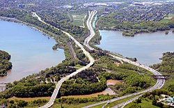
 View of Burlington Heights from Burlington. | |
| Location | Hamilton, Ontario., Ontario, Canada |
| Coordinates | 43°16′14″N 79°53′10″W / 43.27056°N 79.88611°W |
| Elevation | 100 metres (330 ft) |
| Governing body | City of Hamilton |
| Owner | City of Hamilton |
Burlington Heights refers to a promontory or area of flat land sitting elevated (at about 100 metres (330 ft)) above the west end of Hamilton Harbour in the city of Hamilton, Ontario which continues as a peninsula to the north toward the city of Burlington, Ontario. It separates Cootes Paradise Marsh on the west from the harbor on the east. Geologically the Burlington Heights is a sand and gravel bar formed across the eastern end of the Dundas Valley by Glacial Lake Iroquois. It is the northern continuation of the longer Iroquois Bar which extends south into Hamilton.
Burlington Heights is traversed by York Boulevard. In the south, extensive parkland surrounds Dundurn Castle on the east side of the road and the large Hamilton Cemetery on the west side. North of Dundurn Castle a city park is named for Sir John Harvey.
The southern portion of the Burlington Heights was designated as a National Historic Site of Canada in 1929, because of its strategic and military importance to the British during the War of 1812.[1] Dundurn Castle was later designated as a National Historic Site in its own right in 1984. Royal Botanical Gardens is another National Historic Site adjacent to the Burlington Heights National Historic Site. Royal Botanical Gardens owns and manages the properties on the Burlington Heights peninsula north of the Desjardins Canal.
- ^ "Burlington Heights National Historic Site of Canada". Retrieved 2017-05-16.
