| Burnett | |
|---|---|
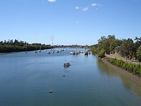
 The Burnett River with the city of Bundaberg on either side | |
Location of Burnett River mouth in Queensland | |
| Etymology | James Charles Burnett[1] |
| Location | |
| Country | Australia |
| State | Queensland |
| Regions | Central Queensland, Wide Bay–Burnett |
| Cities | Mundubbera, Gayndah, Wallaville, Bundaberg, Burnett Heads |
| Physical characteristics | |
| Source | Mount Gaeta, Great Dividing Range |
| • location | near Monto |
| • coordinates | 24°51′S 151°36′E / 24.850°S 151.600°E |
| Mouth | Coral Sea |
• location | Burnett Heads |
• coordinates | 24°45′16″S 152°23′48″E / 24.75444°S 152.39667°E |
• elevation | 0 m (0 ft) |
| Length | 435 km (270 mi) |
| Basin size | 32,220 km2 (12,440 sq mi) |
| Discharge | |
| • location | Near mouth |
| • average | 2,460,984 ML/a (77.9839 m3/s)[2] |
| Basin features | |
| Tributaries | |
| • right | Three Moon Creek, Nogo River, Auburn River, Boyne River, Barambah Creek |
| Reservoir | Paradise Dam |
| [3] | |
The Burnett River is a river in the Wide Bay–Burnett and Central Queensland regions of Queensland, Australia.
- ^ Cite error: The named reference
readwas invoked but never defined (see the help page). - ^ "Drainage Basin: Burnett River". Archived from the original on 6 October 2009. Retrieved 23 June 2023.
- ^ "Map of Burnett River, QLD". Bonzle Digital Atlas of Australia. Archived from the original on 15 December 2019. Retrieved 14 November 2015.
