Burnettown, South Carolina | |
|---|---|
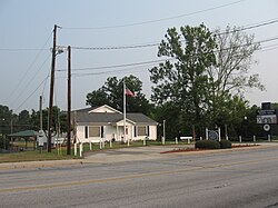
 Former Burnettown Town Hall | |
 Location of Burnettown, South Carolina | |
| Coordinates: 33°30′44″N 81°52′14″W / 33.51222°N 81.87056°W | |
| Country | |
| State | |
| County | |
| Area | |
| • Total | 6.05 sq mi (15.67 km2) |
| • Land | 5.51 sq mi (14.27 km2) |
| • Water | 0.54 sq mi (1.40 km2) |
| Elevation | 180 ft (50 m) |
| Population | |
| • Total | 3,105 |
| • Density | 563.52/sq mi (217.59/km2) |
| Time zone | UTC-5 (Eastern (EST)) |
| • Summer (DST) | UTC-4 (EDT) |
| ZIP code | 29851 |
| Area code(s) | 803, 839 |
| FIPS code | 45-10270[4] |
| GNIS feature ID | 1231108[2] |
| Website | www |
Burnettown is a town in Aiken County, South Carolina, United States. The population was 3,105 at the 2020 census.[5] It is part of the Augusta, Georgia metropolitan area. Burnettown is located in historic Horse Creek Valley.
- ^ "ArcGIS REST Services Directory". United States Census Bureau. Retrieved October 15, 2022.
- ^ a b U.S. Geological Survey Geographic Names Information System: Burnettown, South Carolina
- ^ Cite error: The named reference
USCensusDecennial2020CenPopScriptOnlywas invoked but never defined (see the help page). - ^ "U.S. Census website". United States Census Bureau. Retrieved January 31, 2008.
- ^ U.S> Census Bureau, "Census 2020 Results" https://www.census.gov/search-results.html?searchType=web&cssp=SERP&q=Burnettown%20town,%20South%20Carolina