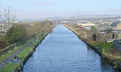
Burnley Embankment | |
|---|---|
 The embankment as viewed from the Finsley Gate bridge | |
| Coordinates | 53°47′19″N 2°14′15″W / 53.78861°N 2.23750°W |
| OS grid reference | SD844324 |
| Carries | Leeds and Liverpool Canal |
| Crosses | Calder valley, Brun valley, Yorkshire Street |
| Locale | Burnley, Lancashire, England |
| Maintained by | Canal & River Trust |
| Heritage status | Grade II listed (partial) |
| Characteristics | |
| Material | Soil (embankment) Stone (Calder aqueduct) Sandstone (retaining walls) |
| Total length | 1,256 yd (1,148 m) |
| Height | 60 ft (18 m) |
| Traversable? | Yes |
| Towpaths | W |
| History | |
| Designer | Robert Whitworth |
| Construction start | 1796 |
| Construction end | 1801 |
| Location | |
 | |
The Burnley Embankment is an embankment carrying the Leeds and Liverpool Canal across the Calder and Brun valleys[1] in Burnley, Lancashire.[2] Also known as the Straight Mile,[2] the embankment is 1,256 yards (0.714 mi; 1.148 km) long[3] and the canal runs up to 60 feet (18 m) above the valley floor.[4] The structure was chosen as one of the original Seven Wonders of the Waterways,[5] and has been awarded a Red Wheel by the Transport Trust.[6]
- ^ "The Culvert". www.bcthic.org. Burnley Civic Trust Heritage Image Collection. Retrieved 29 October 2019.
- ^ a b "Burnley Embankment". canalrivertrust.org.uk. Canal & River Trust. Retrieved 28 October 2019.
- ^ Porter, John (1980). The making of the Central Pennines. Moorland Pub. Co. p. 138. ISBN 9780903485807.
- ^ Fisher, Stuart (2009). The Canals of Britain: A Comprehensive Guide. London: A&C Black. p. 237. ISBN 9781408105177.
- ^ "The seven wonders of the waterways | Canal & River Trust". canalrivertrust.org.uk. Canal & River Trust. Retrieved 28 October 2019.
- ^ Frost, Roger; Thompson, Ian; Dewhurst, Victoria (2014). River Calder. Stroud: Amberley Publishing. p. 64. ISBN 9781445619040.