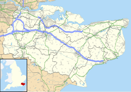
| Geography | |
|---|---|
| Location | River Medway estuary |
| Coordinates | 51°25′16″N 0°40′30″E / 51.421°N 0.675°E |
| Length | 2 km (1.2 mi) |
| Width | 1 km (0.6 mi) |
| Administration | |
England | |
| County | Kent |
| Borough | Swale |
| Demographics | |
| Population | 0 |
Burntwick Island is an island in the estuary of the River Medway in Kent, United Kingdom. It is a flat, raised area of marshland around 2 kilometres (1.2 mi) long and 1 kilometre (0.62 mi) wide among the tidal sand banks on the southern side of the estuary and separated from the British mainland of Chetney Marshes by a narrow channel known as Stangate Creek. The island is crossed by several narrow tidal channels that mean that at high tide the island is separated into several smaller islands.[1]
- ^ Ordnance Survey of Great Britain
