Burrell Township, Indiana County, Pennsylvania | |
|---|---|
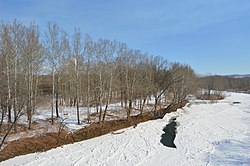
 Along the Conemaugh River south of Blairsville | |
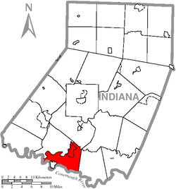
 Map of Indiana County, Pennsylvania Highlighting Burrell Township | |
 Map of Pennsylvania highlighting Indiana County | |
| Country | United States |
| State | Pennsylvania |
| County | Indiana |
| Area | |
| • Total | 24.39 sq mi (63.18 km2) |
| • Land | 23.88 sq mi (61.84 km2) |
| • Water | 0.52 sq mi (1.34 km2) |
| Population | |
| • Total | 3,525 |
| • Estimate (2021)[2] | 3,511 |
| • Density | 175.32/sq mi (67.69/km2) |
| Time zone | UTC-5 (Eastern (EST)) |
| • Summer (DST) | UTC-4 (EDT) |
| FIPS code | 42-063-10352 |
Burrell Township is a township in Indiana County, Pennsylvania, United States. Burrell Township was formed from Black Lick Township in 1853, named after Judge Burrell. The population was 3,525 at the 2020 census,[2] a decline from the figure of 4,393 tabulated in 2010. The township includes the communities of Bell's Mills, Black Lick, Campbells Mill, Fairfield Heights, Josephine, Marshall Heights, Oake's Point, Palmertown, Smith, and Strangford.[3]
- ^ "2016 U.S. Gazetteer Files". United States Census Bureau. Retrieved August 14, 2017.
- ^ a b c Bureau, US Census. "City and Town Population Totals: 2020-2021". Census.gov. US Census Bureau. Retrieved July 6, 2022.
{{cite web}}:|last1=has generic name (help) - ^ "Indiana County Pennsylvania Township Maps".