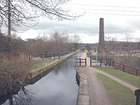
| Burrs Country Park | |
|---|---|
 | |
 | |
| Type | Public and industrial heritage park |
| Location | Bury, UK |
| Coordinates | 53°36′31″N 2°18′17″W / 53.608593°N 2.304844°W |
| Area | 36 hectares |
| Created | 1989 |
| Operated by | Bury MBC |
| Open | All year |
Burrs Country Park covers a 36 hectare (86 acre) site on the banks of the River Irwell, in the town of Bury, Greater Manchester, England. It was acquired by Bury Metropolitan Borough Council in 1986 and transformed from a derelict industrial site into a modern country park.