| Bushahr State | |||||||
|---|---|---|---|---|---|---|---|
| Princely State of British India | |||||||
| 1412 A.D.–1948 | |||||||
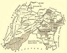
 Bushahr in a map of Punjab, 1911 | |||||||
| Capital | Rampur Bushahr (Last) | ||||||
| Area | |||||||
• 1941 | 8,907 km2 (3,439 sq mi) | ||||||
| Population | |||||||
• 1941 | 115,000 | ||||||
| History | |||||||
• Established | 25 November | ||||||
| 1948 | |||||||
| |||||||
Bushahr, also spelt as 'Bashahr' and 'Bussahir' or 'Bushair' was a Rajput princely state in India during the British Raj. It was located in the hilly western Himalaya promontory bordering Tibet.
Bushahar was eighty four miles long, sixty two miles wide on eastern side, twelve miles wide on the western with an area of 3,820 square miles including that of Saire. The greater part of Bushahr was lying with in the drainage area of the Satluj, which runs from North-West to South-West. After Kashmir it was one of the oldest of the hill state in the Western Himalayas. According to legend Bushahar Dynasty was found by Pradyumana, the son of Lord Krishna. In order to marry the daughter of Banasur, the local chief of Shonitpur (Sarahan). Pradyumana is said to have come to that place after the death of Banasurin an encounter with him, he became the chief of Bushahar and Kinnaura region, since Bushahar had no male heir. Another legend describes Pradyumna the youngest of two brothers who had come from "Kanchanaapuri" in the south on pilgrimage to the "Bhimakali" temple at Sarahan. Since the throne was vacant at the time of death of last Raja without heir. Pradyumana who happened to enter the place gate first at a specified timeas had been ordained by the goddess "Bhimakali" was declared as their ruler. The elder brother was appointed as the priest of the royal family with a jagir at 'Village Rawain' near Sarahan. According to C.F. Kennedy Bushar State was founded by Danwar Singh, an immigrant Rajput from Deccan in 1412 A.D. The seat of government, was at 'Kamru' and from that place, the founder conquered lower hills. But the earlier historical mentions of Bushahar is found in chronicles of Kullu, when it was over run by Maru Verman at the end of 7th century AD Shitthal Pal, the son of Datesh Pal of Kullu, it is said fled to Bushahar and took refuge. So C.F. Kennedy was proven wrong. The territory of this former state is now part of Kinnaur and Shimla districts of the present Himachal Pradesh state. The erstwhile Bushahr state was traversed by the Sutlej river. It was bordered on the west by the Kulu, Lahaul and Spiti states and by Tehri Garhwal on the east. It had an area of 8,907 km2 (3,439 sq mi).