Butler County | |
|---|---|
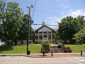
 Butler County Courthouse in Morgantown | |
 Location within the U.S. state of Kentucky | |
 Kentucky's location within the U.S. | |
| Coordinates: 37°13′N 86°41′W / 37.21°N 86.68°W | |
| Country | |
| State | |
| Founded | January 18, 1810 |
| Named for | Richard Butler |
| Seat | Morgantown |
| Largest city | Morgantown |
| Area | |
| • Total | 431 sq mi (1,120 km2) |
| • Land | 426 sq mi (1,100 km2) |
| • Water | 5.4 sq mi (14 km2) 1.2% |
| Population (2020) | |
| • Total | 12,371 |
| • Estimate (2023) | 12,375 |
| • Density | 29/sq mi (11/km2) |
| Time zone | UTC−6 (Central) |
| • Summer (DST) | UTC−5 (CDT) |
| Congressional district | 2nd |
| Website | www |
Butler County is a county located in the US state of Kentucky. As of the 2020 Census, the population was 12,371.[1] Its county seat is Morgantown.[2] The county was formed in 1810, becoming Kentucky's 53rd county.[3] Butler County is included in the Bowling Green, Kentucky, Metropolitan Statistical Area.
- ^ "State & County QuickFacts". US Census Bureau. Archived from the original on June 7, 2011. Retrieved March 5, 2014.
- ^ "Find a County". National Association of Counties. Archived from the original on May 31, 2011. Retrieved June 7, 2011.
- ^ Kleber, John E., ed. (1992). "Butler County". The Kentucky Encyclopedia. Associate editors: Thomas D. Clark, Lowell H. Harrison, and James C. Klotter. Lexington KY: University Press of Kentucky. ISBN 0-8131-1772-0.