| Bybrook By Brook | |
|---|---|
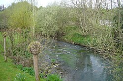
 The Bybrook at Box, Wiltshire | |
 | |
| Location | |
| Country | England |
| Region | West Country |
| District | South Gloucestershire |
| Physical characteristics | |
| Source | Lower Lapdown Farm |
| • location | Tormarton, South Gloucestershire, England |
| • coordinates | 51°29′54″N 2°20′34″W / 51.4983°N 2.3429°W |
| • elevation | 574 ft (175 m) |
| 2nd source | Folly Farm, South Gloucestershire |
| • location | Cold Ashton, South Gloucestershire, England |
| • coordinates | 51°27′23″N 2°21′44″W / 51.4565°N 2.3621°W |
| • elevation | 623 ft (190 m) |
| Source confluence | Nettleton Mill House |
| • location | Castle Combe, Wiltshire, England |
| • coordinates | 51°29′55″N 2°14′13″W / 51.4985°N 2.2369°W |
| • elevation | 262.5 ft (80.0 m) |
| Mouth | Bristol Avon |
• location | Batheaston, Bath and North East Somerset, England |
• coordinates | 51°24′06″N 2°18′37″W / 51.4016°N 2.3102°W |
• elevation | 66 ft (20 m) |
| Length | 12 mi (19 km), south |
| Discharge | |
| • average | 57.25 cu ft/s (1.621 m3/s) |
| • minimum | 4.95 cu ft/s (0.140 m3/s) |
| • maximum | 487.6 cu ft/s (13.81 m3/s) |
| Basin features | |
| River system | Bristol Avon |
The Bybrook, also known as the By Brook, is a small river in England. It is a tributary of the Bristol Avon and is some 12 miles (19 km) long. Its sources are the Burton Brook and the Broadmead Brook, which rise in South Gloucestershire at Tormarton and Cold Ashton respectively, and join just north of Castle Combe in Wiltshire. The river has a mean flow rate of 57.25 cubic feet per second (1.621 m3/s) as recorded at Middlehill near Box. A variety of flora and fauna is supported by the river including the endangered white-clawed crayfish. Twenty watermill sites have been identified on the river but none now remain in use.