Bylas, Arizona | |
|---|---|
 Historic Bylas Town marker | |
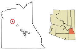
 Location of Bylas in Graham County, Arizona. | |
| Coordinates: 33°07′45″N 110°07′00″W / 33.12917°N 110.11667°W | |
| Country | United States |
| State | Arizona |
| County | Graham |
| Indian Reservation | San Carlos Apache Indian Reservation |
| Area | |
| • Total | 4.20 sq mi (10.88 km2) |
| • Land | 4.18 sq mi (10.83 km2) |
| • Water | 0.02 sq mi (0.05 km2) |
| Elevation | 2,622 ft (799 m) |
| Population (2020) | |
| • Total | 1,782 |
| • Density | 426.21/sq mi (164.55/km2) |
| Time zone | UTC-7 (Mountain (MST)) |
| ZIP code | 85530[3] |
| Area code | 928 |
| FIPS code | 04-08710 |
| GNIS feature ID | 2582743[2] |
Bylas (Western Apache: Hago'teełe[citation needed]) is an unincorporated community and census-designated place in Graham County, Arizona, United States, located within the San Carlos Apache Indian Reservation. As of the 2010 census, its population was 1,962.[4] The community has a medical clinic, a police substation, and a market. Bylas is an Apache settlement divided into two communities, one of the White Mountain Apache, the other of San Carlos and Southern Tonto Apache. It is named for Bylas (a.k.a. Bailish) a chief of the Eastern White Mountain Apache band.
- ^ "2020 U.S. Gazetteer Files". United States Census Bureau. Retrieved October 29, 2021.
- ^ a b U.S. Geological Survey Geographic Names Information System: Bylas, Arizona
- ^ "Bylas AZ ZIP Code". zipdatamaps.com. 2023. Retrieved February 17, 2023.
- ^ "U.S. Census website". United States Census Bureau. Retrieved May 14, 2011.

