6°00′00″S 40°00′00″W / 6.0000°S 40.0000°W
You can help expand this article with text translated from the corresponding article in Portuguese. (April 2014) Click [show] for important translation instructions.
|
| Caatinga | |
|---|---|
 Caatinga | |
 Map of the Caatinga ecoregion. | |
| Ecology | |
| Realm | Neotropical |
| Biome | deserts and xeric shrublands |
| Borders | |
| Geography | |
| Area | 730,850 km2 (282,180 sq mi) |
| Countries | Brazil |
| States | |
| Coordinates | 7°36′46″S 39°26′01″W / 7.612796°S 39.433699°W |
| Conservation | |
| Conservation status | Vulnerable |
| Protected | 44,133 km² (6%)[1] |
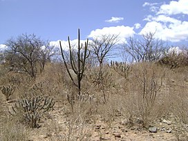
Caatinga (Portuguese pronunciation: [kaaˈtʃĩɡɐ]) is a type of semi-arid tropical vegetation, and an ecoregion characterized by this vegetation in interior northeastern Brazil. The name "Caatinga" comes from the Tupi word ka'atinga, meaning "white forest" or "white vegetation" (ka'a = forest, vegetation, tinga = white). The Caatinga is a xeric shrubland and thorn forest, which consists primarily of small, thorny trees that shed their leaves seasonally. Cacti, thick-stemmed plants, thorny brush, and arid-adapted grasses make up the ground layer. Most vegetation experiences a brief burst of activity during the three-month long rainy season.
Caatinga falls entirely within earth's tropical zone and is one of 6 major biomes of Brazil. It covers 912,529 km²,[2] nearly 10% of Brazil's territory. It is home to 26 million people[3] and over 2000 species of plants, fish, reptiles, amphibians, birds, and mammals.
The Caatinga is the only exclusively Brazilian biome, which means that a large part of its biological heritage cannot be found anywhere else on the planet.
- ^ Eric Dinerstein, David Olson, et al. (2017). An Ecoregion-Based Approach to Protecting Half the Terrestrial Realm, BioScience, Volume 67, Issue 6, June 2017, Pages 534–545; Supplemental material 2 table S1b. [1]
- ^ da Silva., J. M. C.; Barbosa, L. C. F.; Leal, I. R.; Tabarelli, M. (2017). Caatinga. Springer. pp. 3–19.
- ^ Salcedo, I.H., Menezes, R.S.C. (2009): Agroecosystem functioning and management in semi-arid Northeastern Brazil, in: Tiessen, H., Stewart, J.W.B. (eds.): Applying Ecological Knowledge to Landuse Decisions. Inter-American Institute for Global Change Research - IICA-IAI-Scope, Paris, pp. 73–81.