Comuna de Cabo de Hornos
Comuna de Cabo de Hornos | |
|---|---|
| Comuna de Cabo de Hornos, Chile | |
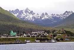
 Puerto Williams, seat of the commune of Cabo de Hornos | |
| Coordinates: 54°56′S 67°37′W / 54.933°S 67.617°W | |
| Country | |
| Region | |
| Province | Antártica Chilena |
| Founded as | Navarino |
| Foundation | December 30, 1927 |
| Government | |
| • Type | Municipality |
| • Alcalde | Patricio Fernández (DC) |
| Area | |
• Total | 15,853.7 km2 (6,121.1 sq mi) |
| Elevation | 39 m (128 ft) |
| Population (2017 Census)[4] | |
• Total | 2,262 |
| • Density | 0.14/km2 (0.37/sq mi) |
| • Urban | 1,952 |
| • Rural | 310 |
| Sex | |
| • Men | 1,403 |
| • Women | 859 |
| Area code | 56 + 61 |
| Website | Official website (in Spanish) |

Cabo de Hornos (Cape Horn) is a Chilean commune located in the south of Tierra del Fuego archipelago, in Antártica Province, Magallanes Region. The municipality of Cabo de Hornos, located in the town of Puerto Williams, also administers the Antártica commune. It is named for Cabo de Hornos, or "Cape Horn", the southern tip of South America.
- ^ "Asociación Chilena de Municipalidades" (in Spanish). Retrieved 27 January 2011.
- ^ "Municipality of Cabo de Hornos" (in Spanish). Retrieved 27 January 2011.
- ^ "Territorial division of Chile" (PDF). Archived from the original (PDF) on 14 November 2010. Retrieved 11 September 2010.
- ^ a b "National Statistics Institute" (in Spanish). Retrieved 20 December 2010.


