Cabo de Santo Agostinho | |
|---|---|
| Municipality of Cabo de Santo Agostinho | |
 Location in the state of Pernambuco and Brazil | |
| Coordinates: 8°17′23″S 35°1′48″W / 8.28972°S 35.03000°W | |
| Country | |
| Region | Northeast |
| State | |
| Area | |
| • Total | 445.343 km2 (171.948 sq mi) |
| Elevation | 29 m (95 ft) |
| Population (2022[2]) | |
| • Total | 203,440 |
| • Density | 460/km2 (1,200/sq mi) |
| Time zone | UTC−3 (BRT) |
| HDI (2010) | 0.686 – medium[3] |

Cabo de Santo Agostinho (English: Cape of St. Augustine) is a 448 square kilometer sized municipality located 35 kilometers south of the city of Recife, Pernambuco, Brazil. It is believed by some historians that Vicente Yáñez Pinzón had set anchor in a bay in Cabo de Santo Agostinho on January 26, 1500, however the Portuguese discovery of Brazil was by Pedro Álvares Cabral on April 21, 1500 is officially recognized instead.[4] Cabo de Santo Agostinho was incorporated as a town in 1811.
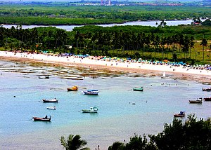
Cabo de Santo Agostinho has both an industrial section that is centered on the Suape port and many tropical beaches and nature reserves. The best-known beaches are Chalets, Paraíso, and Gaibu.[citation needed] Recanto do Domingos lies at the far south end of Pedra do Xareu beach.[citation needed]
- ^ "Brazilian Institute of Geography and Statistics" (in Portuguese). 2017. Retrieved 27 March 2019.
2018 Area Total
- ^ IBGE 2022
- ^ "Archived copy" (PDF). United Nations Development Programme (UNDP). Archived from the original (PDF) on July 8, 2014. Retrieved August 1, 2013.
{{cite web}}: CS1 maint: archived copy as title (link) - ^ Morison, Samuel (1974). The European Discovery of America: The Southern Voyages, 1492–1616. New York: Oxford University Press.


